India’s First Private L-Band SAR Satellite: XDLINX and Sisir Radar Signal a New Era in Earth Observation
In May 2025, a major milestone was announced that positions India at the forefront of synthetic aperture radar (SAR) innovation. XDLINX Space Labs, a dynamic player in agile satellite technology, and Sisir Radar, a pioneer in SAR systems, revealed their strategic partnership to develop India’s first privately-built L-band SAR satellite.
The satellite, expected to launch by 2027, will be powered by Antaris satellite software, signaling a leap in software-defined, modular satellite platforms tailored for commercial and defense ISR (Intelligence, Surveillance, and Reconnaissance) applications. The partnership not only strengthens India’s indigenous capabilities but also positions the country among a select group of nations with privately operated SAR imaging systems.
Revolutionizing Radar Imaging Through Private Innovation
Radar imaging has long been dominated by large government space agencies due to the complexity and cost of deploying SAR satellites. However, the collaboration between XDLINX and Sisir Radar marks a paradigm shift in the commercial space domain. This venture is a strong testament to the capability of India’s private sector to lead high-impact technological development.
Dr. Tapan Misra, Founder and Chief Scientist of Sisir Radar, emphasized the significance of this development, stating:
“This partnership marks a significant milestone in our journey to democratize access to advanced radar imaging. By combining our expertise in SAR technology with XDLINX’s agile satellite platforms, we’re setting new benchmarks for what private industry can achieve in space.”
Rupesh Gandupalli, Co-Founder and CEO of XDLINX, added:
“Collaborating with Sisir Radar enables us to embed next-generation SAR capabilities into our platforms, opening new frontiers for strategic applications and Earth observation. We are proud to contribute to advancing India’s space ecosystem, driven by a shared vision of innovation.”
What Makes L-Band SAR Special?
While SAR satellites can operate in various frequency bands (X, C, L), the L-band is known for its superior penetration ability through vegetation and clouds, making it especially useful for applications like:
-
Agricultural monitoring
-
Forestry and biomass estimation
-
Disaster response and flood mapping
-
Military surveillance
-
Infrastructure deformation tracking
Unlike optical satellites, SAR satellites work day and night, regardless of weather conditions, ensuring continuous Earth observation—a capability increasingly important in the era of climate change and geopolitical tensions.
India’s Rising Momentum in Earth Observation: NISAR and Beyond
XDLINX and Sisir Radar’s announcement comes at a time when India’s Earth observation ecosystem is expanding rapidly.
Also in May 2025, ISRO Chairman Dr. V. Narayanan announced the scheduled launch of the long-awaited NASA-ISRO Synthetic Aperture Radar (NISAR) mission. NISAR is a collaborative Earth observation satellite equipped with dual SAR payloads developed by NASA and ISRO, capable of tracking surface deformation, glacial movement, agricultural cycles, and natural disasters with unprecedented accuracy.
The synergy between government missions like NISAR and private projects like the XDLINX-Sisir Radar satellite underscores India’s commitment to becoming a global hub for geospatial intelligence and radar imaging.
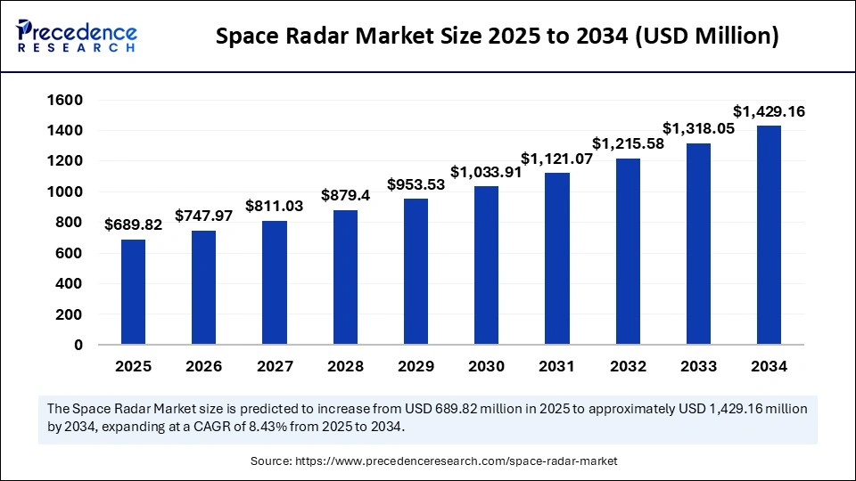
Space Radar Market Size and Forecast 2025 to 2034
According to Precedence Research, the global space radar market size is estimated to hit around USD 1,429.16 million by 2034 increasing from USD 636.19 million in 2024, with a CAGR of 8.43%.
Global SAR Activity: Japan and China Scale Up
India is not alone in recognizing the strategic value of radar satellites. In May 2025, Japan’s iQPS (Institute for Q-shu Pioneers of Space) launched QPS-SAR-10, their 10th satellite in an ambitious plan to build a 36-satellite constellation. Positioned in a 575 km circular orbit with a 42-degree inclination, the satellite is part of Japan’s initiative to deliver frequent revisit radar imaging for use cases such as:
-
Urban planning
-
Disaster early warning systems
-
Maritime surveillance
Despite setbacks in 2022, including launch failures, Japan’s commercial SAR players are steadily advancing toward a goal of 24 satellites by 2027, aiming for sub-meter resolution and low latency in global imaging services.
Meanwhile, China, through its China Aerospace Science and Technology Corporation (CASC) and subsidiary Shanghai Academy of Spaceflight Technology (SAST), launched two radar-equipped SuperView Neo-2 satellites in November 2024. Operating under the umbrella of China Siwei, this expansion supports dual-use applications—spanning national defense, environmental monitoring, and economic development.
These global developments reflect a strategic space race, where radar imaging becomes a crucial tool for environmental governance, national security, and economic insights.
Role of AI in SAR Imaging and Satellite Operations
The future of radar imaging is not just about hardware—it’s increasingly being defined by software intelligence. The XDLINX-Sisir Radar project leverages Antaris software, which enables:
-
Modular satellite development
-
On-orbit software updates
-
Cloud-integrated mission control
Moreover, AI and machine learning are revolutionizing how SAR data is interpreted:
-
Change Detection: AI algorithms can detect landscape changes over time—such as deforestation, urban sprawl, or illegal mining—with high speed and accuracy.
-
Disaster Monitoring: During floods, earthquakes, or landslides, AI-enhanced SAR systems enable real-time assessment of affected zones.
-
Maritime Surveillance: Deep learning models help differentiate vessels, detect suspicious activity, and monitor illegal fishing operations.
-
Predictive Analytics: AI-driven tools forecast ground deformation risks, contributing to safer infrastructure development.
With India becoming a powerhouse in AI talent, integrating AI with SAR satellites offers a strategic edge in data intelligence and Earth analytics.
Opportunities Ahead for India’s Private Space Sector
The XDLINX-Sisir Radar collaboration marks a defining moment for India’s emerging private space ecosystem, which has seen policy liberalization and venture capital interest in recent years. Key opportunities include:
-
Exporting radar imaging services to defense and commercial users worldwide.
-
Supporting climate resilience through near-real-time terrain data for agriculture, forestry, and water management.
-
Driving space-tech employment across software, hardware, and analytics domains.
-
Developing modular satellites for specific applications like smart cities, energy infrastructure, and national security.
India’s combination of high engineering talent, competitive manufacturing costs, and supportive policy frameworks makes it well-placed to become a global hub for SAR-based space solutions.
Challenges in Radar Satellite Expansion
Despite the momentum, several challenges must be addressed:
-
High development costs for radar payloads and launch services.
-
Regulatory hurdles in frequency allocation, export controls, and international compliance.
-
Limited launch capacity, though initiatives like ISRO’s SSLV (Small Satellite Launch Vehicle) and private rockets from Agnikul and Skyroot may ease this bottleneck.
-
Data security and dual-use concerns, especially for satellites capable of military surveillance.
Addressing these challenges will require industry-government collaboration, international partnerships, and continued investment in R&D.
India’s SAR Ambitions Take Flight
The XDLINX-Sisir Radar partnership is more than just a satellite mission—it’s a signal to the world that India is ready to lead in radar-based Earth observation. With global peers like Japan and China scaling their own SAR constellations, India’s strategic positioning and innovation-led approach could carve a niche in high-resolution, intelligent radar imaging.
Also Read: Space Radar Market